Koguryo generally has the tag of a warlike kingdom, and I always assumed that it was the least culturally developed of the Three Kingdoms of Korea.
Amongst other things, however, it was responsible for the world’s earliest complete map of the stars.
This planispheric star map is believed to have been produced in 1395, the years after the official beginning of the Joseon dynasty. However, we can date the outer section to Koguryo by the positioning of the stars. As the earth rotates on its axis every 25,800 years, the positions of the stars will change subtly according to the epoch in which they are made.
The chart depicts the 1,467 stars visible to the naked eye from the Korean peninsula.
The inscription states that the pattern was based on a rubbing taken from the original map, which was destroyed by an invading force. Since the time period implied by the stellar positions on the map places it in the first century AD, this makes it the oldest complete representation of the sky in the world.
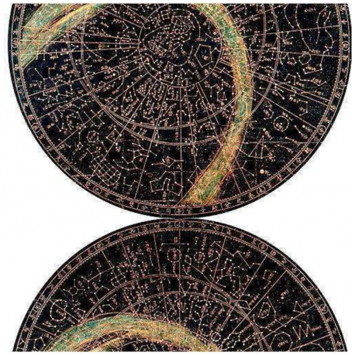
The positioning of the stars on the map also reveals from where the measurements were taken. The positions of the circumpolar stars in the inner region places the North Pole at 38° north latitude, which corresponds to Hanyang (Seoul), the capital of Choson. The region of the stars enclosed by the outer circles of the map implies 39-40° north latitude, corresponding to Koguryo, which occupied the northern part of the Korean peninsula and much of southern Manchuria.
Star maps in Japan, such as the 7th century ceiling work of the Kitora Tomb in the village of Asuka, show evidence of having been calculated from a base of 38.4° north latitude, closer to Koguryo (39°) than (34.5°). 1.2km away from the site of the map is the Takamatsu tomb, which contains murals depicting a group of ladies in Koguryo costume, implying that it was an area settled by Koguryo immigrants.
A study of the positioning of the stars depicted in the Kitora chart has also confirmed that it is a projection of the heavens some two millennia ago, which corresponds to the early Koguryo period, like the Chonsang yolcha punya chido.